
The Route
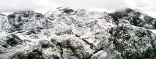
Ben Nevis
We will be starting with Ben Nevis both to avoid leaving the biggest to last, and to avoid such a long drive home after the event. We plan to start around 6pm, using the midsummer light to get well down from the summit before dark, but equipped with head torches for a return in the dark if necessary. We will be starting from the car park at the Glen Nevis visitor centre rather than from the youth hostel, which will add a few minutes to our time.
Ben Nevis is magnificent. At 4,409 feet, it is by far the biggest mountain of the three, and as we start at just about sea level, it will be by far our biggest climb. We will be taking the "Tourist" Path - I think it says something about the Scottish sense of humour that the tourist path is a 4,350 foot ascent that leads you to the edge of a 2,000 foot precipice with overhanging snow cornices! Ben Nevis can be a serious undertaking - even at the end of June we expect to find snow on the top, whether covering the summit or just in smaller patches. In mist near the summit the sheer drops over the edge of the cliffs into Gardyloo Gully and Tower Gully are a significant danger, particularly if the path is obscured by snow. We will have a note of the all important compass bearings to follow from the trig point at the summit for a safe descent.
From Ben Nevis, according to the AA, it's a 6 hour road trip to Wasdale Head in the Lake District. Driving at night, we hope to avoid the traffic and do it in five and a half hours, but we have to allow up to six and a half hours to be safe.
Scafell Pike
 At 3,206 feet, Scafell Pike, the highest
mountain in England, is the smallest of the three peaks. However, the
route we will be taking from Wasdale Head gives us the steepest climb of
any of the three with 2,995 feet ascent in only 2.5 miles. What's more the
summit of Scafell Pike is one huge pile of boulders, with the roughest
walking of the trip. With plenty of cracks between the stones, we will
have to watch for our ankles here. In bad visibility, navigation is a
challenge too. At around 5am, with the end of the challenge nowhere yet in
sight, Scafell Pike will probably be the toughest of the three peaks! We
will be aiming to be up and down in 4 hours.
At 3,206 feet, Scafell Pike, the highest
mountain in England, is the smallest of the three peaks. However, the
route we will be taking from Wasdale Head gives us the steepest climb of
any of the three with 2,995 feet ascent in only 2.5 miles. What's more the
summit of Scafell Pike is one huge pile of boulders, with the roughest
walking of the trip. With plenty of cracks between the stones, we will
have to watch for our ankles here. In bad visibility, navigation is a
challenge too. At around 5am, with the end of the challenge nowhere yet in
sight, Scafell Pike will probably be the toughest of the three peaks! We
will be aiming to be up and down in 4 hours.
From Wasdale Head to Pen-y-Pass for Snowdon is a four and a half hour drive according to the AA, and with the daytime traffic, we will be pleased if we can better that.
Snowdon
Snowdon, the highest mountain of Wales, is 3,560 feet high, and is a good walk at the best of times. We will be taking the Pyg Track from Pen-y-Pass, which reduces the climbing to 2,381 feet, but after Ben Nevis and Scafell Pike it certainly won't be an afternoon stroll! If we have been within our target times up till now, then allowing for a little time at the start and end of each mountain, we will have around 4 hours left for Snowdon. If bad weather or bad traffic have slowed us down, then we will be up against it as a reasonable target for most of us at this stage of the challenge is three and three quarters hours. Only time will tell!
Click here to read about the team
![]()
![]()
![]()